Storm Chasing Blog returns!

24 Dec 2014

Hi all, my storm chasing blog from my 2 1/2 months dedicated storm chasing in Tornado alley in the USA has returned to the web! Below you can view the videos and a few photos and my experiences, weather observations, forecasting and documenting these severe weather events. Photos of my storm chasing are in my portfolio.

Welcome to my storm chasing adventures!

27 Apr 2014

Hi everyone. This is my first ever blog. My name is Aaron Stanley and I’m from Melbourne.

Currently at Dallas/Fort Worth waiting for my flight to Tulsa where I will meet up with a mate of mine who will be taking me out storm chasing. This is my third season storm chasing here in Tornado Alley and this time will be the longest stay doing what I love, storms, lightning and forever changing scenery. Whilst tornadoes may be visually stunning, we all know what they are capable of. Like everyone else, I don’t like the death and destruction that comes with them.

It’s been quite a journey to get here. A one hour flight to Sydney, then the exhausting 14 hour 20 minute flight direct to Dallas. At least it was shorter due to the jet streams in our favor. Now the one hour flight to Tulsa.

I’ll keep everyone updated on the events to follow over the next few months; hopefully getting a chance to post some live photos now and then. Until then, here is a photo from the 2012 season near Roswell New Mexico.

Wall cloud near Roswell, New Mexico USA 13th May 2012.

Wall cloud near Roswell, New Mexico USA 13th May 2012.

TORNADO ALLEY

27 Apr 2014

Ok so we started the day in Tulsa (Oklahoma). Drove up to Joplin (Missouri) following a line of storms traveling in a North/East direction. We then proceeded north up to Carl Junction, Nashville, across to Pittsburg (Kansas) and finally half way between Joplin and Springfield. All the time following a few cells; some of them tornado warned. Once again hearing the tornado sirens for real and not being tested really brings things into perspective. Quite a few times you could see the cloud lowering, inflow tails and rotation. Lots of hail, Mammatus, lightning and heaps of driving! About 450 miles today….. Great day, but unfortunately hearing later this evening about the deaths across the three states was not good at all. My friend told me he did not want to go chasing in Arkansas due to the tricky terrain and what a good decision that was. Prayers for all those people affected by today’s storms/tornadoes. May they rest in peace.

EF-3 Cordova, Nebraska.

11 May 2014

So the weather had been quiet here for about a week until Sun 11th May. We positioned ourselves in Emporia, Kansas the day before. Then the chase started from about midday on Sunday. We headed north through Manhattan and stopped at Marysville to gather data and to see what the storms were doing. We then proceeded north towards Milford, Nebraska where we started to see a beautiful collar cloud – which was attached to the cloud base above the wall cloud. These collar clouds are associated with tornadic producing super cells.

From the reflectivity and velocity we could see a huge tornado but at the time could not visually see it…. I’ll get to that reason shortly.

We then started criss-crossing our way through the network of country and dirt roads to try and get a better viewing position and to stay ahead of the Tornado. Sometimes encountering the huge inflow of air being sucked up into the super cell up to and in excess of 80mph winds.

We then reached Milford and tried multiple times to reach highway 6 that ran parallel to interstate 80. But each time we were turned back by the huge forces of the rain wrapped tornado. We knew that the tornado was there, but could not see it due to the rain curtains. With a HP (High Precipitation) super cell like this one we encountered, the rain bands wrap around the tornado. At one stage as we turned around, we were in the outer circulation of the tornado, now that we know it was an 1.5 mile wide EF-3. A HP super cell is very dangerous for the reason you can’t see it until it’s too late.

We then dropped back to watch a lovely rotating super cell that was to the south west of the main tornado producing cell. As from the video I posted you can see the whole cloud structure rotating around itself.

The video is almost 10 minutes in length but it is worth watching the entire video. Go pro footage outside the car and hand held video from inside the car!

After this we continued east on interstate 80 driving parallel to the main cell towards Lincoln and then onto Omaha and then based ourselves in Council Bluffs, Iowa. Here we experienced the bruit force of mother nature at its best. I took a few photos of the city of Omaha, then as the storm moved through we experienced storm force winds in excess of 80mph. I had thought that we were encountering the tornado itself. The rain was sandblasting our car, the nearby trees leaning on angles never seen before. Just with one super cell, I had seen the most amount of lightning I have ever seen in my entire life!

Over the two days we traveled to 5 states; Oklahoma, Kansas, Nebraska, Iowa and Missouri. Such a great road trip and one rain wrapped wedge tornado I’ll never forget.

Most picturesque tornado!

16 Jun 2014

June 16th was one of those once in a life time events. We crept up on the most picturesque tornado I’ve ever seen. Revealing itself from behind the rain curtains this classic funnel leisurely made its way through the fields just north west of Burwell, Nebraska.

It was different to see a tornado on this side of the supercell (NW side) as it is usually hidden by a rain/hail core. Most tornadoes are viewed from the South West side of the supercell. This supercell’s mesocyclone was cycling at the time. Throwing out tornadoes all around it and it just so happened to see this cycle as the rain curtains cleared. Seeing a tornado in its sheer beauty like this is an unforgettable experience.
June 17th – Our day started out in North Sioux City, South Dakota. We were trying to make our way towards the Coleridge/Laurel area. With not many options to cross the river and stay safe due to the major flooding and storms in the area, we had no choice to stay north of the Missouri river until Yankton then head south for an intercept. Also with road closures we eventually made our way to Laurel where we would witness the birth of a wedge tornado with multiple sub vortices. This large wedge tornado sat just north of Laurel for approximately one hour almost stationary!

The only time we could see this tornado and its sub vortices was when the lightning lit up the sky or during power flashes. Power flashes are when power lines or houses etc are damaged which causes the electricity to light up the surrounding area. Luckily enough only damage was reported to some farm sheds, crops and machinery.

We were running pretty low on fuel at this stage and needed to find a gas station that was open, so we headed out of Laurel in search of fuel. After some time we found a gas station where it was a pleasure to briefly meet Matt Phelps, another chaser who shares the same passion as ours. He is a tour guide with Extreme Tornado Tours, just one of the tour companies that offer storm chasing holidays. After getting some gas we were off again, this time to witness the monstrous structure of the supercell and the fascinating lightning show.

June 18th – Driving near Blair, Nebraska we had seen damage by wind driven hail up to 4” in size. There were trees that had been stripped bare of their leaves; such a weird sight to see.

June 29th – I met the one and only Randy “outlaw’ Hicks! A veteran in storm chasing and well respected in the chasing community. Also was a pleasure to meet his chasing partner Lisa McGeough. We spent the day chasing with them in Nebraska and Iowa. This time we actually drove through the town of Blair and saw the devastation of the wind driven hail. Not far out of Blair we came across the formation of a wall cloud, and a few brief funnels. We followed this storm through some un-chaseable countryside, only getting a visual when on top of each hill. After making the decision to call it a day, we spotted a nice cell firing up behind the original one we were following. Within minutes it was tornado warned and went for an intercept. You can hear in the video the old style tornado sirens. Placing ourselves in the ‘hook’ and looking up at this beast of a mesocyclone was amazing! The hook echo weather radar signature is a classic feature of tornado producing supercell. The signature being produced by precipitation held aloft that wraps around the mid-level mesocyclone. Unfortunately no tornado was produced, just a few brief funnels.

You can follow Randy here – https://www.facebook.com/TheOutlawChasers

That escalated quickly! Just golf balls!

25 Jul 2014

It was late May and all was calm. Eric and I had traveled all the way up to South Dakota for a possible few chase days. Driving through some magnificent country side and passed Mt. Rushmore which we made a stop at during our rest days. So the 28th of May we were passing through the town of Glasgow, Montana and were asked by some French chasers if they could interview us about storm chasing. They were part of the French media who were in the USA filming their storm chasing holiday. After providing them with some tips on how to stay safe around these super cells, we continued on to Malta, Montana where we intercepted a beautiful shelf cloud during an amazing sunset and an abandoned house as a picture perfect location! Many areas of rotation and very strong straight line winds in Malta which picked up a lot of dust. But unfortunately no tornadoes with this cell.

That night we met a great group of people from Canada on a chasing holiday. They had a pretty heavily armored vehicle to withstand some large hail!


On the 6th of June we caught up with the Canadians and went chasing in Texas centered around the town of Channing. We tried multiple attempts to access a super cell which had produced a tornado, but due to the high precipitation of the cell it was too hard to see beyond the rain curtains. Following this cell for a few hours as it tracked east until the cell died. The terrain also became un-chaseable with canyons, so we called it a day.

On the 8th Of June it was time for New Mexico! We had chased there before, but this was chasing with a difference…… 6000ft elevation! The road network was not that great so we had to ‘punch a core’ which was dropping 2inch hail – very scary. Actually only missing the three inch hail by about 500m. Once we were through it revealed a beautiful wall cloud. Stopping to watch it drop many small brief multi vortex tornadoes just south of Wagon Mound.

Upon returning to the other side of the storm, we found approximately 30 cars with broken windscreens and hail damage. Because of the elevation, the hail was really dense so did the maximum amount of damage. We followed this storm east where the elevation suddenly dropped 2000ft and the storm dissipated, but reformed around Amarillo, Texas later that evening.

On the 14th of June, Eric and I were live streaming on behalf of KAKE news Witchita, Kansas. We were able to get an EF-0 tornado just north west of Stockton. It was on the ground for a few minutes, not fully condensed, but a spectacular rope tornado that we got reasonably close to. That night also capturing a night time rope tornado that touched down near Giltner, Nebraska. Great day out chasing!

Thanks to Eric Duncan my driver and forecaster! Was great to be able to chase with some new Canadian friends – Craig Hilts (Craig’s photography Page – https://www.facebook.com/prairiefirephoto), Gunjan Sinha & Rossanna Purvis Gregory. A credit to all the good chasers out there, and what a team we made!

Last Chase Day

15 Aug 2014

Our last chase day was a bit unexpected. Tired from the previous three days out on the road, I woke up and decided to check the forecast. To my amazement, there was a moderate chance of severe weather predicted about 3 ½ – 4 hours north of us. So….. We hit the road for our ‘last chase day’! We were running short on time as we had confirmation of a tornado on the ground south west of Des Moines moving in an east-north easterly direction a couple of hours away at that stage. Approximately 50 miles south of the tornado warned super cell we could start to see the cloud formations, striations and mammatus looking clouds. Unfortunately we were unable to catch the fast moving super cell, so we posted in Chariton, Iowa for a short while. Then deciding to head back to the Iowa/Missouri state line at Lineville. We were able to catch a severe thunderstorm which turned tornado warned just north of Albany, Missouri.

Heading north on interstate 35 we were forced to stop to let it pass in front and then continued on our way. Strangely enough through the town of Ridgeway which was completely deserted, they had been under a tornado warning where everyone had gone into their shelters or basements. The video is very creepy.

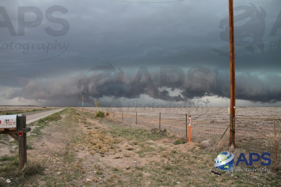
Because the mesocyclone (meso) was cycling at the time (no tornado, but signs of redeveloping), it was safe to punch through into the meso through the rain curtains. Once we did this we were right under the meso which was a beautiful sight to see. Trying to stay in front of the rain curtains and the rear flank downdraft (RFD). This is the region of dry air that wraps around the back of the meso, an area of descending air which often shows up as the hook (Hook echo) in which you’ll hear Eric stay that we will thread the hook for as long as we can. In simple terms, we’ll follow right under the area ‘where the magic happens’ for as long as we can! We definitely encountered some rough terrain that day, but at least we could see what was happening most of the time. Eventually the tornado warning was dropped and we continued to follow the severe warned storm until we got to Mill Grove and decided to call it a day.

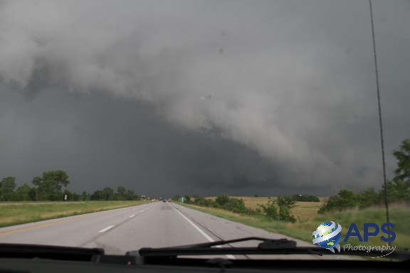
Heading back to Kansas City, Missouri – There was a whole line of storms that were turning into a MCS (Mesoscale Convective System) when usually the cells join and generally loose the potential to form tornadoes. However in this case one tornado was reported quite far north on this MCS. Upon returning to Kansas City, we had settled in when an emergency broadcast came over the TV. A tornado warning was in effect in our area. So we jumped in the car and headed east on interstate 24 to try and catch a glimpse. However, due to the terrain and being night time we were unable to see it. So…. That was our last chase day. Definitely not short of action!

IN SUMMARY – Over the 2 ½ months we did approximately 15,000 miles! (26,000kms!) That’s the equivalent of driving from the South Pole to the North Pole….. Plus a little extra! We covered 12 states – Oklahoma, Kansas, Nebraska, South Dakota, North Dakota, Montana, Wyoming, Iowa, Missouri, Arkansas, Texas and New Mexico.

I am still sifting through approximately 200 gig of video and photos, so I’ll keep posting onto the blog in the near future.

While I do have the time, I will thank those who made my vacation one of the best trips in my life that I’ll remember for many years.

Eric Duncan – A great mate, thank you for personally taking me out for 2 ½ months full time storm chasing. I have managed to learn a lot about forecasting and reading storms. We had some great times! Meagan – Thanks for putting up with me for the duration of my stay. Both of your hospitality was greatly appreciated.

The Canadian’s – Craig Hilts, Gunjan Sinha & Rossanna Purvis Gregory. So much fun had together and I cannot wait to meet up again sometime soon.

Randy Hicks & Lisa, Matt Phelps – Was a pleasure to meet you all, stay safe and hope to see you all again soon.

One last post is below......

Sunset delight – Malta, Montana

25 Aug 2014

I have put together a video with some Gopro and digital camera footage of a beautiful severe thunderstorm near Malta, Montana. In the first part of the video you will see a small round cloud start to form above the old house, this is a small mesocyclone that had started to form and could see it rotating. A scud cloud also forms at the corner of the house and moves to the left of the screen. This scud cloud looks like it is caught in the outflow as it’s moving away from the storm and these are too often mistaken for tornadoes. You can also clearly see the inflow of moist air move in to the storm, the clouds forming and moving into the storm. These storms can pull air into it from tens of miles or further away. At the end of the video you will see that we are in the town of Malta where we get hellacious outflow from the storm. Bringing with is very intense winds and dirt/dust. This outflow is the cool air coming out of the storm also known as a gust front in some instances. No tornado was produced from the storm.